


*The colour tone of the listed products may differ from the actual product in some cases.
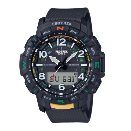
PRG-240 Series
PRG-240-3
Introducing new Tough Solar and Triple Sensor PRG-240 model colours for the PRO TREK lineup of serious outdoor gear watches. Khaki and sand beige earth tone coloured bands create the perfect look for outdoor gear timepieces. The orange and yellow colours used for the two front buttons and the inlaid bezel text were selected for their higher visibility. A dual-layer LCD that can simultaneously display different types of data combines with a register ring for simple bearing indication creates a practical design. The dual-layer liquid crystal makes it possible to show a blue compass pointer overlaid on the current timekeeping display, for outstanding versatility. The compass, barometric pressure/altitude and temperature measurement functions, are powered by a Tough Solar system that keeps functions operating even with exposure to small amounts of light. The innovative arrangement of the large buttons that trigger compass, barometric pressure/altitude and temperature measurement enable one-touch operation even when wearing gloves. Button guards encase the outside surfaces of the buttons with resin that prevents misoperation. In addition to being practical and highly functional, These PRG-240 models are also designed to go well with today's outdoor fashions. • Triple Sensor: Bearing, barometric pressure/altitude, temperature • Tough Solar • Low-temperature specifications (–10℃/14℉) • 100-metre water resistance • Bearing bezel
Features
-
Great for climbing
-
Stable solar power
-
10 bar water resistant
-
Lets you know your direction
-
Lets you know the barometric pressure and altitude
-
Lets you know the temperature
Specifications
TECHNOLOGY FEATURES
SOLAR-POWERED
(TOUGH SOLAR)
This proprietary CASIO solar-powered battery-recharging system assures stable operation of various power-hungry functions, including dial lighting, alarms, stopwatches and measurement functions.

Measuring altitudes based on changes in atmospheric pressure
The altimeter determines the altitude at your current location based on accumulated atmospheric pressure changes measured by the pressure sensor. Setting the altimeter at a location where you know the precise altitude before starting your ascent enables it to take even more precise altitude measurements.
Sea level measurement
Setting the altimeter at a location where you know the precise altitude enables you to determine the elevation of your current position with respect to sea level. If you come across a marker indicating 400 meters above sea level while hiking or climbing, for example, simply set the altimeter at 400 meters. This enables you to obtain more accurate readings with respect to sea level when you take subsequent measurements after moving on.
Altitude memory
The altitude memory stores data on the month, date, time and results of altitude readings taken automatically at regular intervals and displays the highest and lowest altitudes measured as well as the cumulative ascent/descent altitude and relative altitude. This data provides an easily understandable summation of your ascents and descents during a climb.

- Cumulative ascent altitude : total of ascent altitudes (A + C)
- Cumulative descent altitude : total of descent altitudes (B + D)
- Highest altitude : altitude measured at the highest point E among all readings during memory measurement
- Lowest altitude : altitude measured at the lowest point F among all readings during memory measurement
- Highest/lowest previous record altitudes
- Sum of cumulative ascent/descent altitudes : computed repeatedly at time of memory measurements between 0 and 99,995 meters
Altitude differential display
Checking against contour lines on a map enables you to confirm your cumulative ascents/descents. Determining the height of your hourly ascents by resetting the altitude differential display once an hour can be helpful in establishing a reasonable climbing plan, for example.

*These measurement functions are not intended for use as professional instruments. Please use the measured data for reference purposes only.
Forecasting the weather based on the atmospheric pressure tendency
A graphic display of atmospheric pressure readings taken at regular intervals reveals pressure trends at a glance. When the pressure is rising, the weather is likely to improve; when it's falling, there's usually worse weather ahead. This feature can remind you to take your swimming suit along, or alert you to approaching trouble.

Atmospheric pressure tendency graph / Atmospheric pressure tendency indicator
The barometer measures the atmospheric pressure every two hours automatically and displays the recent atmospheric pressure tendency and the current pressure graphically.

Aligning a map with the surrounding terrain
If you determine magnetic north with the direction measurement function and place a map beside your watch, you can align the map with the surrounding geography.
Magnetic declination correction
You can change the direction measurement standard from “magnetic north” to “true north” by inputting the magnetic declination data indicated on a topographical map to correct the direction.

Bearing Memory [selected models only]
The Bearing Memory memorizes directions detected by the direction measurement function and displays them continuously in graphic format. You can travel straight toward your destination by following a course determined with the memorized direction displayed steadily in the 12 o’clock position on your watch face. This capability also comes in handy when visibility is low due to such factors as trees or fog.

Predicting your destination temperature based on the temperature at your current location
The temperature generally decreases by approximately 6.5°C with every increase in altitude of 1,000 meters, or 3.6°F with every increase of 1,000 feet. If the temperature at 1,000 meters is 10°C, therefore, the temperature at 3,000 meters will probably be about -3°C.

Aligning a map with the surrounding terrain
If you determine magnetic north with the direction measurement function and place a map beside your watch, you can align the map with the surrounding geography.
Magnetic declination correction
You can change the direction measurement standard from “magnetic north” to “true north” by inputting the magnetic declination data indicated on a topographical map to correct the direction.
